


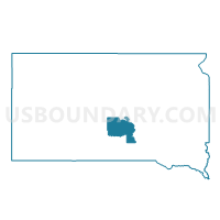
VTD-precinct 6 Reliance, Lyman County, South Dakota
About
Outline

Summary
| Unique Area Identifier | 667503 |
| Name | VTD-precinct 6 Reliance |
| County | Lyman County |
| State | South Dakota |
| Area (square miles) | 158.73 |
| Land Area (square miles) | 158.24 |
| Water Area (square miles) | 0.50 |
| % of Land Area | 99.69 |
| % of Water Area | 0.31 |
| Latitude of the Internal Point | 43.93999040 |
| Longtitude of the Internal Point | -99.61792210 |
Maps


Graphs
Select a template below for downloading or customizing gragh for VTD-precinct 6 Reliance, Lyman County, South Dakota


Neighbors
Neighoring Voting District (by Name) Neighboring Voting District on the Map
- VTD-precinct 4 Oacoma, Lyman County, SD
- VTD-precinct 7 LowerBrule, Lyman County, SD
- VTD-precinct 9 Kennebec, Lyman County, SD
Top 10 Neighboring County Subdivision (by Population) Neighboring County Subdivision on the Map
- Lower Brule UT, Lyman County, SD (1,481)
- Reliance town, Lyman County, SD (191)
- East Lyman UT, Lyman County, SD (148)
- Central Lyman UT, Lyman County, SD (105)
- Rex township, Lyman County, SD (30)
- Bailey township, Lyman County, SD (14)
- Pleasant township, Lyman County, SD (3)